In an era where online information is often accepted as truth without considering the source's credibility, misconceptions about global geography are rampant. This article tackles this issue head-on by debunking 30 commonly misunderstood geographical facts, helping to clear up confusion and set the record straight.
"Antarctica Has Zero Time Zones"
Contrary to popular belief, Antarctica spans all 24 time zones and hosts approximately 82 research facilities from 30 different countries. These facilities typically follow their home countries' time zones. Occasionally, they align with the TZ Database. However, this may be puzzling for residents during the summer months, when continuous daylight creates a 24/7 illuminated environment.
Time in Antarctica is complex due to its lack of ownership or governance. Managed by TZ Database, the continent is divided into nine zones based on pre-existing territorial claims, though not universally recognized. Overlapping claims and logistical hurdles further complicate matters. Moreover, Antarctica experiences months-long stretches of continuous daylight or darkness
"Russia and Turkey Are the Only Countries That Span Two Continents"
There are five transcontinental countries on the Europe-Asia border, Russia, Kazakhstan, Azerbaijan, Turkey, and Georgia. Europe and Asia connect along the Caucasus watershed between the Black Sea and the Caspian Sea. The Greater Caucasus mountain range consists of some of the highest mountains in Europe, including the highest mountain in Europe, Mount Elbrus in Russia. There are also the Javakheti Plateau and the Armenian highlands in the south that lie in Turkey territory.

Georgia and Azerbaijan lie alongside Russia in the northern regions of the Greater Caucasus mountain range but also extend south to the Lesser Caucasus mountain range alongside Iran, a few other independent states, and the self-proclaimed Republic of Artsakh. The countries in the Caucasus region are unique and diverse, as they combine elements from Europe and Asia to create an independent identity.
"The Statue of Liberty Is in New York"
The jurisdiction of the Statue of Liberty is a topic that riles many local New Yorkers and New Jersey folk. Liberty Island, owned by the federal government, covers an area of 14,717 acres (5,956 hectares). The island lies in the Upper New York Bay, 610 meters from Liberty State Park in New Jersey and 2,6 kilometers from the Battery Park in New York. Although the island is in Jersey waters, it forms part of the Manhattan borough in New York.

Following a long dispute over the boundary line between the states, in 1834, the US Congress ratified an agreement, setting the boundary at the center of the shared water, except that Liberty Island and Ellis Island, which fall in New Jersey waters, would remain part of New York. In 1908 the US Supreme Court confirmed the ruling.
"The Nile River Is the Longest River"
The Nile river in Africa was once considered the longest river on earth. However, in 2007, Brazillian scientists discovered an alternative source to the Amazon River. It measured six miles longer than the previously recorded origin. They also measured the outlet via the southern channels, adding another 219 miles to its length.

Today, the Amazon is recorded at 4,225 miles (6,800 kilometers) long, and the Nile measures 4,132 miles (6,650 kilometers), making the Amazon the winner by just under 100 miles. The recognized method of measuring a river is the longest distance, of continuous flowing water, from the point of origin to the ocean. It is complicated and often difficult to pinpoint exact points of reference. Where the Amazon river flows into the Atlantic ocean, fresh water is found over 100 miles from shore during the rainy season.
"Florida Is the Southern-Most State in the United States"
We have looked at the furthermost north, east, and western regions. Now we explore the south. The southernmost state on the American continent is Florida. However, the southernmost state is Hawaii. The Hawaiian capital, Honolulu, lies 1464.61 miles (2357.06 km) north of the equator, and Orlando-Florida is 1,971.81 miles (3,173.32 km) north of the equator.

The southernmost town in the United States is Nā'ālehu in Ka Lae, Hawaii. Meanwhile, the Amundsen-Scott South Pole Station in Antarctica is the southernmost region under the United States' jurisdiction. A monument in the image of an enormous buoy is erected on coral bedrock on the Key West coast of Florida, signaling the southernmost point of the continental United States.
"The Mississippi River Is the Longest River in the United States"
Another misconception about the longest rivers is between the Mississippi and the Missouri River. They form part of the Jefferson-Mississippi-Missouri River system, which is currently the fourth largest river system globally. It flows through 31 states across America and two provinces in Canada- an area of over 1 million square miles!

According to mapsofworld.com, Missouri is the longest river in the US at 2,341 miles. It originates in the Rocky Mountains in Montana and joins with the Mississippi to the north of St. Louis. It is known as "Big Muddy" or "Dark River" due to the high silt content coloring the water. The Mississippi River is a close second with a recorded length of 2,202 miles. It originates at Lake Itasca in northern Minnesota and flows to the Mississippi River Delta in the Gulf of Mexico.
"Maine Is the Eastern-Most State in the United States"
When comparing different aspects across America, many Americans forget to include Alaska, which became a state in 1959. Alaska is the easternmost, westernmost, and northernmost state in the country. You may wonder how this is possible.

The 180-degree meridian runs directly through the Aleutian Islands in Alaska, putting part of the area in the eastern hemisphere and the other part in the western hemisphere. The prime meridian sits at 0 degrees longitude and is used as a starting point to measure distance east or west around the world. Therefore the 180-degree meridian would indicate the furthermost position both east and west. If you exclude the northern state of Alaska, Maine is the easternmost state.
"Florida Has the Longest Coastline of All the States in the United States"
Once again, people overlook Alaska. Many Americans believe that Florida has the longest coastline of all the other states. It looks the part and perhaps has the most coastline conducive to vacationing. The Alaskan coastline is longer than all the combined coastlines in America. There are two methods of measuring a coastline. The NOAA includes the shoreline of Great Lake and tidal inlets, and the CRS only calculates ocean coastlines and excludes tidal inlet methods

The total combined coastlines in the United States are 95,471 miles (153,652.12 km) using the NOAA method and 12,479 miles (20,083 km) using the CRS calculation. The coast in the state of Alaska measures 33,903 miles (54,563 km). Indiana has the shortest shoreline, at only 45 miles (72 km) long.
"All 50 States Observe Daylight Saving"
Most states adjust their clocks to accommodate daylight saving, but not all. In the United States, daylight saving time (DST) is implemented each year on the second Sunday in March and terminates on the first Sunday in November. Hawaii, and territories abroad, including American Samoa, Puerto Rico, Guam, the Northern Mariana Islands, and the United States Virgin Islands, have chosen not to follow DST.

Most of Arizona does not observe daylight saving. However, the Navajo tribal lands adjust their clocks accordingly. The Uniform Time Act of 1966 established daylight saving. Each state chooses whether or not to conform to DST at the start of a daylight saving period via legal procedures. Before 1968 Arizona observed DST but then enacted the exemption statute and has since not followed daylight saving. They hoped to conserve energy consumption with shorter summer days.
"Norway Is the Northernmost Country"
Comparing regions this far north is not a straightforward task as extreme weather conditions cause the land to change continuously. However, Kaffeklubben Island of Greenalnd, near Cape James Hill and 6.2 miles northwest of Bliss Bay, currently stands as the most northerly permanent land remaining above water.

The distance from Kaffeklubben Island to the geographic North Pole measured only 443.3 miles. It is a small island, only approximately 2,300 feet long by 980 feet wide. The close contenders for the northernmost country are Russia, Canada, and Greenland. The town of Alert in Canada is the closest permanently inhabited settlement from the pole. It is 508 miles away with a population below 100.
"Mount Whitney Is Top of the Peaks in the United States"
Here is another example of how people forget to include Alaska. Many people count Mount Whitney as the tallest mountain in the United States. That would be true if you exclude Alaska. Alaska is home to ten of the highest peaks among the states, with Denali in south-central Alaska, formerly known as Mount McKinley, which means "the tall one" in the native dialect, taking the top position.

The US Department of the Interior changed the name in August 2015. Denali was accepted as the tallest mountain. However, there were numerous disputes on the actual height of Denali. In 2015, an expedition set out to settle the disputes. Armed with the latest technology and geoid models, they provided the now accepted recording of 20,310 feet. Just over 1,000 international climbers apply for permits each year.
"Route 66 Is the Longest Highway in the United States"
Route 66 may be one of the most iconic and revered highways in the United States, but it is not the longest. It is featured in numerous popular songs, including Nat King Cole's song "Route 66," where he sings about “The highway that’s the best.” Route 66 measures a distance of 2,448 miles (3,940 km), whereas the longest highway, Route 20, runs from coast to coast for 3,365 miles (5,415 km) through 12 states, including Oregon, Idaho, Montana, Wyoming, Nebraska, Iowa, Illinois, Indiana, Ohio, Pennsylvania, New York, and Massachusetts.

Each state maintains the highway within its territory. The roadway is double laned except for 8.45 miles in the east, which expands to four lanes. The area between Wyoming and Valentine forms one of the scenic byways in Nebraska.
"Florida Has the Longest Coastline of All the States in the United States"
Once again, people overlook Alaska. Many Americans believe that Florida has the longest coastline of all the other states. It looks the part and perhaps has the most coastline conducive to vacationing. The Alaskan coastline is longer than all the combined coastlines in America. There are two methods of measuring a coastline. The NOAA includes the shoreline of Great Lake and tidal inlets, and the CRS only calculates ocean coastlines and excludes tidal inlet methods.

The total combined coastlines in the United States are 95,471 miles (153,652.12 km) using the NOAA method and 12,479 miles (20,083 km) using the CRS calculation. The coast in the state of Alaska measures 33,903 miles (54,563 km). Indiana has the shortest shoreline, at only 45 miles (72 km) long.
"Alaska’s Population Is Smaller Than Any Other in the United States"
In earlier years, Alaska did have the smallest population. The United States Census Bureau recorded the population as 33,426 in 1880. One hundred years later in 1980, the population increased to 401,851. In February 2020, thoughtco.com placed Alaska as the fourth smallest population in the United States, with a count of 741,894

The smallest population was recorded in Wyoming at 585,501 people, followed by Vermont with 624,594, then North Dakota with 755,393. South Dakota was in fifth place with a population of 865,454. The United States is the third most populated country, with over 330 million people and a population density of 94 people per square mile. California has the highest population, with close to 40 million inhabitants, followed by Texas with over 30 million people and Florida with around 22 million
"The Verrazano Narrows Is the World’s Longest Bridge"
The Verrazano Narrows Bridge connecting Staten Island and Brooklyn is a magnificent example of prime engineering that spans 13,700 feet (4,176 meters). However, it is nowhere near the longest bridge in the world, placing at a low 149 on the list. The top contenders are Danyang-Kunshan Grand Bridge in China, measuring 540,700 feet (164,800 meters).

The Beijing-Shanghai High-Speed Railway has reduced travel time significantly. Previously travel from Ningbo to Jiaxing via public transport would take four and a half hours and now it takes only two hours. It took 10,000 people four years to construct, officially opening in 2011 and costing $8.5 billion. The second-largest bridge is the Changhua–Kaohsiung Viaduct in Taiwan. It is a High-Speed Railway line built-in 2004. By December 2012, over 200 million passengers had traveled by train over the bridge measuring 97 miles.
"Orlando Is the Capital of Florida"
Surprisingly Tallahassee is the capital of Florida. Although it seems like a remote choice, council members chose it in 1824 for its location. Florida became an American territory in 1821. The Legislative Council of the Territory of Florida held its first meeting at the former West Florida capital Pensacola. However, it took attendees from St. Augustine in East Florida 59 days to travel by water.

The subsequent meeting in St. Augustine meant a dangerous journey for the West and took 28 days. Delegates decided to host the next meeting at a destination halfway between both former capitals, choosing Tallahassee as the destination. It is now the 8th-largest city in Florida, and the 126th-largest city in the United States, with a population of 192,885. It has a large number of college students who attend Florida State University.
"Krakatoa Lies East of Java"
The Krakatoa volcano lies in the Sunda Strait between Sumatra and Java islands in Lampung, Indonesia. The most significant eruption occurred in 1883. The explosion was approximately 13,000 times more ferocious than the atomic bomb in Hiroshima, expelling about six cubic miles of rock. Residents of Alica Springs, Australia, 2,200 miles away even reported hearing the eruption.

It was such a monumental event that in 1968 the film Krakatoa, East of Java was released. The movie caused many people to believe that Krakatoa lies east of Java. You may remember the devastating tsunami of 2018 that hit just before Christmas. The collapse of a large portion of the southwest side of Anak Krakatoa caused the tsunami that resulted in 426 fatalities, over 14,000 injuries and damages to 2,752 houses and 510 ships.
"Kashmir Region Is in India’s Territory"
The Kashmir region in the north of the Indian subcontinent is a disputed territory that overlaps the borders of India, Pakistan, and the People’s Republic of China. England's departure from India in 1947 led to its partition into India and Pakistan, driven by religious differences. This partition sparked tensions over the princely state of Kashmir, as its Hindu ruler chose to join India, causing a dispute with Pakistan that persists today.

In 1962 border disputes in the east between the Indians and Chinese led to the Sino-Indian War. The Himalayas occupy a large portion of the area. There are also three rivers, the Indus, Jehlum, and Chenab, whose river basins split the region into three valleys. This choice triggered disputes and led to the current territorial distribution and ongoing tensions.
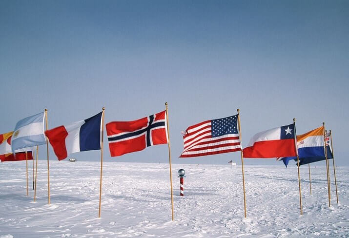
"The South Pole Lies Within Antarctica"
This one is a little more complex than the other topics discussed because there are four south poles. The Geographic South Pole is the point of interception between the Earth's crust and axis, situated at Amundsen–Scott South Pole Station, established by the United States in 1956. The Inaccessible South Pole is the centermost position in Antarctica or the furthermost point from shore.

The Geomagnetic South Pole is the point of intersection between the geomagnetic fields and the Earth's surface. Lastly, the Magnetic South Pole is the point on the Earth's crust where the magnetic fields intersect. In 2005 the south magnetic pole lay between Adélie Land and Wilkes Land off the Antarctic coast. However, it is moving at a rate of six to nine miles annually and is currently an estimated 1,780 miles from the Geographic South Pole.
"Canada Is the Largest Country in the World"
Russia is, by far, the world's largest country, having the same surface area as the dwarf planet Pluto. According to Worldometer, it covers an area of 6,601,665 square miles (17 million km) which is approximately eleven percent of the earth's land mass. Canada is the second biggest country at 3,855,101 square miles (9,9 million km). China and the United States of America are a close third and fourth with 3,747,877 and 3,618,783 square miles, respectively.

Traveling east to west, you would pass through eleven time zones in Russia and six in Canada. The Russian Federation spans Northern Asia and Eastern Europe. Russia has a population of approximately 146 million. Despite being nearly half the size, China's population currently sits at over 1,450 billion. Russia also contains around one-quarter of fresh liquid water on earth.
"Matterhorn Is the Highest Mountain in Europe"
People often mistake the picturesque Matterhorn mountain on the border between Switzerland and Italy as the highest mountain in Europe. At 14,692 feet, it is one of the highest summits in the Alps and Europe. Edward Whymper led a party of seven climbers on the first ascent of the Matterhorn mountain in 1865. Four of his crew died during the descent.

The north face forms part of "The Trilogy," the three tallest north faces in the Alps, was first ascended in 1931, and the higher west face, was first summited in 1962. The Matterhorn remains one of the deadliest mountains, with around five hundred fatalities. However, it is nowhere close to the colossal height of Mount Elbrus in Russia. Mount Elbrus lies within the Caucasus mountain range in southern Russia and peaks at 18,510 feet or 5,642 meters.
"The Capital of Canada Is Toronto"
Toronto is the financial, arts, and cultural hub of Canada. It is home to a diverse population and is known for its multi-culture. Over 160 other languages are spoken in the region, but most Torontonians speak English as their primary language. It also has the highest populous of any other city in Canada. However, one thing it does not have is the title of the capital city, which goes to Ottawa.

In 2016, MoneySense rated cities in Canada, and Ottawa came out as the best place to live. As the political hub of Canada, many of the 1,488,307 residents within the metropolitan are employees of the federal government. There is also a large number of students in the region who attend the numerous education and research facilities.
"Africa Is a Country"
Australia is the only country that is also a continent. Africa has 54 heavily populated countries on the continent. Its more than 1.3 billion inhabitants contribute to approximately 16% of the global population. Economically, Africa is the poorest continent per capita. Positioned over the equator and the prime meridian makes Africa the only continent to straddle all four cardinal hemispheres.

Africa is home to more megafauna than anywhere else. Some extant mammals in this category found on the continent include rhinoceroses, elephants, zebras, giraffes, hippos, and large bovines. The African elephant is the largest land mammal on earth, weighing between 11,500 and 17,600 pounds (5,200 to 8,000 kg). There are approximately 1,500 to 2,000 different languages spoken across Africa. In fact, South Africa has 11 official languages, Afrikaans, English, isiZulu, isiNdebele, Pedi, Sesotho (Sotho), siSwati (Swazi), Xitsonga (Tsonga), Tswana, Tshivenda (Venda), isiXhosa.
"The Capital of Switzerland Is Geneva"
When you think of cities in Switzerland, Geneva and Zurich are probably the first two that pop into your mind. However, the centrally situated city of Bern is the capital. It was one of the first cantons to join the Swiss Confederacy in 1353 and became a federal city in 1848. The old town is a treasure trove of medieval and gothic architecture. In 1983, UNESCO declared the entire old town a world heritage site, one among 144 across Switzerland.

If you are ever fortunate enough to visit Switzerland, you should include Bern in your itinerary. Some must-sees include the famous Zytglogge, a medieval clock tower featuring elaborate architecture, and a mechanical figure of Chronos, which strikes the hour bell. Bern also has 4 miles of covered promenades, one of the longest covered shopping boulevards in Europe.
"Holland Is a Country"
Many people picture Holland as a country with tulips and windmills. However, Holland is not a country but a province of the Netherlands, one of twelve. Some of the largest and better-known cities fall within the North and South Holland provinces, including Amsterdam and Haarlem in North Holland and Rotterdam and the Hague in South Holland.

People often say Holland when referring to the Netherlands as a whole. Even the locals of the Holland provinces don't mind, but the residents of the other ten provinces don't appreciate it. The Netherlands is the lowest-lying country with the highest population density in Europe. There are actually more bicycles than people. Over 90% of the population is proficient at speaking English.
"Greenland Has a Larger Landmass Than Africa"
When studying a Mercator map, the land areas near the poles look disproportionately large. It is why many people think that Greenland can rival the likes of Africa in size. It is deceiving. Greenland is 836,300 square miles, while Africa is around 14 times larger, covering 11,730,000 square miles. Greenland can actually fit into the Democratic Republic of Congo.

The Mercator mapping system is a cylindrical system established in 1569 to assist navigation at sea. It shows the vertical and horizontal lines plotting the lines of longitude and latitude. When a world map is converted from a 3D globe to a flat 2D map, the scale of the map becomes a bit distorted. The areas near the poles appear enlarged, while the equatorial regions appear diminished in size.
"Great Britain Is Another Term for the United Kingdom"
People often use the term Great Britain and the United Kingdom interchangeably. However, there is a difference between the two. Great Britain is not a country but a land mass within the British Iles that includes the countries England, Scotland, and Wales. The British Isles is a collection of thousands of islands off the northwestern mainland Europe, including Great Britain, Ireland, The Isle of Man, The Isles of Scilly, and The Channel Islands.

The United Kingdom is a sovereign state encompassing England, Scotland, Wales, and the UK constituent country, Northern Ireland. England is the largest country in the United Kingdom, covering just over half of Great Britain, with a population of over 56 million. The capital city of London has a population of about nine million and is one of the most densely populated cities in Europe.
"Puerto Rico Is an Independent Country"
Puerto Rico is an island in the Caribbean about 1,000 miles southeast of Miami. It is an unincorporated territory administered by the United States. The dominant language is Spanish, although English is also an official language. There is a population of approximately 3.2 million people, with the capital city of San Juan being the most populous.

Puerto Rico is relatively small, only 100 miles by 35 miles. Christopher Columbus discovered and claimed the island in 1493 on his second exploration of the Americas, and after the Spanish-American in 1898, it became part of the United States. The United States controls the economy, trade, air and boat traffic, education, and judicial system of Puerto Rico. Citizens pay US taxes, are entitled to benefits, and do not require passports or visas to travel to mainland America.
"Iceland Is, as the Name Suggests, Covered in Ice"
This statement is categorically false. Despite its location, the coastal regions of Iceland generally remain ice-free during winter. The North Atlantic Current is responsible for raising the temperature, and Iceland has warmer temperatures than most other areas along the same latitude. In June 1939, Iceland experienced a record high air temperature of 86.9 °F (30.5 °C) at Teigarhorn on the southeastern coast.

The lowest temperature ever recorded was a bone-chilling −36.4 °F (−38 °C) at Grímsstaðir and Möðrudalur in January 1918. However, the Capital city, Reykjavík, experiences average temperatures of between 49.6 °F (9.8 °C) and 54.9 °F (12.7 °C) in June and between 28.8 °F (−1.8 °C) and 37.6 °F (3.1 °C) in January. Iceland forms part of the Mid-Atlantic Ridge and has approximately 130 volcanoes, many of which erupt constantly.
"Sydney Is the Capital City of Australia"
Usually, when we think of a country's capital city, we picture the most popular city. So when we consider Australia, we think of either Sydney or Melbourne. Those were the first choices of the Australian government too. However, they reached a compromise and decided to build their capital city in New South Wales, approximately 100 miles from Sydney.

Construction of Canberra began in 1913. It was an entirely planned city designed by American architects Walter Burley Griffin and Marion Mahony Griffin. It is the eighth-largest city in Australia and the largest inland, with a population of over 430,000. The Ngunnawal people and other indigenous people inhabited the region for around 21,000 years before the Europeans settled there at the start of the 19th century. Did you know that The National Library in Canberra contains every book published in Australia?
"Lagos Is the Capital City of Nigeria"
If you are not current with world affairs, particularly on the African continent, you probably haven't realized Lagos is no longer Nigeria's capital. The West-African country is the most populated country on the African continent, with a population of over 216 million people. Nigeria is a multinational state with over 250 ethnic groups and 500 dialects.

The population growth in Lagos is reportedly 3,000 people per day, equating to 1.1 million people annually. In 2022 the population was approximately 28 million. Before 1991, Lagos was the national capital, but the government decided to relocate it to the central city of Abuja in the Federal Capital Territory. Abuja is another planned city. The design, based off of the master plan of Kenzo Tange, a Japanese architect, was constructed during the 1980s and named the Capital city on 12 December 1991.
Africa Is the World's Second-Largest Continent
Embark on a journey of discovery as we unravel intriguing insights that will reshape your understanding of this remarkable continet. From its stunning landscapes to its vibrant cultures, join us in unearthing the hidden gems that define Africa's unique identity.

54 Is Nothing
Of the seven continents on Earth, only Asia is bigger in size, but none has more countries than Africa’s 54. It might sound like a lot of countries, considering it’s more than 27 percent of all those on earth, but 54 is nothing compared to how divided Africa used to be.

Most, if not all, of Africa’s modern borders and states have been created by colonialism, but before European countries began dividing the continent between themselves, Africa was made up of an estimated 10,000 different states and autonomous groups. Every single one had its own distinct languages and customs. Now, that’s diversity!
11 Million Miles
Africa might only be the second largest continent on the planet, but that doesn’t mean it isn’t big. The last time it was measured, we assume not using a tape measure, it clocked in at an almost unimaginable 11,724,000 square miles.

That’s a square mile for every resident of New York and Chicago put together. Usually split into five “bite-size” subsections- North Africa, East Africa, Central Africa, Southern Africa, and West Africa - Africa makes up around 20% of the landmass on Earth.
Top of the Hots
From the desert regions of the north to the farms and safari parks of the south, the dominant weather across Africa is dry and sunny. While, obviously, such a vast continent is home to a whole range of diverse climates, almost 60% of its land is desert.

Temperatures over 40°C are common in many areas of Africa but these are nothing compared to the hottest temperatures ever recorded on earth. In the northeastern town of El Azizia, Libya, thermometers once topped out at a terrifying measurement of 58°C. Conversely, the record for the lowest temperature recorded in Africa is −23.9 °C, in Ifrane, Morocco.
Doubting Thomases
El Azizia in Libya entered the record books when it reached 58°C, but not everyone is happy with accepting that fact. Investigative scientists have since questioned the methods used to reach that figure, the accuracy of the recording, and - ultimately - the authenticity of the claim.

Officially, at a temperature of 56.7°C, recorded way back in 1913, Death Valley in California is the world’s hottest place, but you might find that fact debated pretty hotly (sorry) on the streets of El Azizia.
Big Sands
Ok, so we know that Africa is big, we know that it’s hot, and we know that huge sections of it are desert. Those facts don’t really put the scale of Africa’s deserts into context. The Saraha, the largest desert in the world, is currently around 3.5 million square miles in size.

The 48 states that make up the continental USA total just 3.2 million square miles. That’s a mind-blowing amount of sand. It’s also worth noting the Sahara is growing by about six miles a year, so it’ll eventually be bigger than all 50 states combined.
Lost Trees
When we think about deforestation, it's probably the Amazon rainforests that spring to mind first. The problem in South America is not to be underestimated, but it is not the only part of the planet to be suffering. In fact, Africa's deforestation rate is twice the average rate for the rest of the world.

The nation’s mighty deserts are growing, but its life-sustaining forests have shrunk to worrying levels and are continuing to be destroyed every day. Around four million hectares of African forest are destroyed each year and, in some countries, less than 1% of the primary forest remains.
Multi-Lingual
How many languages do you speak? How many languages do you think are spoken in your town? Or your country? Single figures? Double? More than 100? Whatever your guess, it’s nothing compared to Africa’s reality. Even the most conservative estimates claim there are more than 1000 languages spoken across the African continent.

Some believe Africa might even be home to more than 3000 different tongues. It’s been calculated that more than a quarter of all of the different languages that are spoken in the entire world can be heard in Africa.
Arabic Comes Top
It might also surprise you which language is the most widely spoken on the African continent. At 170 million speakers, the latest figures show that Arabic is the most common language.

Arabic is dominant in many of the northern countries such as Algeria, Chad, Comoros, Djibouti, Egypt, Libya, Mauritania, Morocco, Sahrawi Arab Democratic Republic, Somalia, Sudan, Tanzania, and Tunisia. English comes second with 130 million speakers. Followed by Swahili, French, Berber, Hausa, and Portuguese, but we really are just scratching the surface with these examples.
Word of Mouth
Language barriers in Africa aren’t restricted to misunderstandings from speaking different dialects either. When it comes to communicating through reading and writing, up to half a billion members of Africa’s population might struggle to understand.

Due to the poor distribution of resources and high levels of poverty across its landmass, around 40% of Africa’s residents are believed to be illiterate. That figure rises closer to 50% in some of the most deprived areas such as Ethiopia, Chad, Gambia, Sierra Leone, Senegal, Niger, Benin, and Burkina Faso.
Space Race
We all know about the 1960s space race between the US and the USSR, but did you know there was another runner? One citizen of Zambia thought his nation should be the one to get to the moon first.

Zambia wasn’t prepared to stop at the moon either, and applications were put in for a grant of more than $8 million to begin a program that would send 12 astronauts and, crucially, a cat to Mars. Sadly, the funding was denied and the Zambian space explorers were prevented from taking their feline friend into outer space.
Twin Town
With a population of over 200 million inhabitants, Nigeria is home to almost twice as many people as any other African country and nearly two-thirds as many people as the entire USA. Within this population, it has also developed a quirky habit of producing twins.

Official figures suggest that the likelihood of twins being born in West Africa is around four times as high as it is anywhere else in the world. The epicenter of this epidemic is Igbo-Ora, a small town in Nigeria where every 1000 births produce around 50 sets of twins.
Deadliest War
When you think of history's deadliest wars, you’re likely to come up with the usual suspect: World War I, World War II, and perhaps even the Napoleonic campaigns across Europe and Russia. One of the deadliest conflicts ever to occur, however, was the Second Congo War which ran from 1998 to 2002.

Seven countries became involved in the deadly conflict which left more than five million dead. That’s a million more than even the most inflated estimates of Vietnam or Korean War casualties. When totaled up with the casualties from the First Congo War just a year earlier, the figure reaches more than six million.
Shortest War
While not as deadly as the conflict in the Congo, Africa was also home to another of the world’s most unique wars. In August 1896, Sultan Khalid bin Barghash succeeded the pro-British Sultan Hamad bin Thuwaini to the throne of Zanzibar.

Britain was not pleased with this development and launched an attack on the sultan’s palace. 38 minutes after the assault was launched, Sultan Khalid bin Barghash surrendered. Soon after, he fled to German East Africa and left the British to sort out a new ruler in his place.
Malaria Nation
While it isn’t required for every nation, European and American visitors to many areas of Africa will be advised to take a course of tablets to prevent Malaria infection when they travel.

While it’s a potential inconvenience to most tourists, Malaria is a deadly threat to millions of Africans who live without the resources to fight the mosquito-carried disease. It’s estimated that 90% of all Malaria cases across the world occur in Africa, and up to 3,000 children die of the disease every single day on the continent.
So Close
It’s tempting to think of the African and European continents as being worlds apart. In many ways, they are, but when it comes to actual distance, it’s a very different story. The Strait of Gibraltar, which separates African Morocco and European Spain, is just nine miles wide.

That’s four miles shorter than the island of Manhattan in New York City. In fact, the continents are so close that Morocco and Spain are in ongoing discussions about building an undersea rail tunnel between the two shores.
Old School
You might have heard of some of the oldest established universities in the world. Oxford and Cambridge in England, Italy’s University of Bologna and University of Padua, Spain’s University of Salamanca, and the University of Valladolid. What about the University of Timbuktu?

When it was established in the 12th Century, Timbuktu in Mali was a center of academia sometimes referred to as the “Paris of Medieval times”. Built in 982, The University of Timbuktu is one of the oldest schools in the world.
Big Frog
How big is a frog? They range from tiny to about fist size, right? Not in Africa. As you might have guessed, the country with one of the most diverse wildlife populations in the world has outdone the rest of the planet when it comes to frogs.

Found mostly in Equatorial Guinea and Cameroon, the Goliath Frog can reach almost a foot in length and weigh close to 8lb. Y’know, about as heavy as a human baby. You should see the size of the lily pads!
Gold Standard
The American West is famous for its gold rush, and Australia has enjoyed its moments in the mineral sun too, but nowhere on earth compares to Africa when it comes to gold deposits.

Though it has now been mostly stolen by Western colonizers, almost half the gold ever mined was found in Africa. Witwatersrand in South Africa is the gold capital of the world. No wonder so many European countries have tried to claim the region. And that’s without even taking all those diamonds into account.
Mammoth Beasts
They can’t compete with some of the sea dwellers, but elephants are famously the biggest animal still walking on earth. Which is bigger though, African or Asian elephants? This is a list of facts about Africa, so obviously this one is included because the answer is African.

These ginormous mammals can grow up to seven meters long and six tonnes in weight. In short, they're massive. They’ve also got bigger ears and more wrinkles, but that usually doesn’t make it onto their Tinder profiles.